


Geophysical, Acoustic, and Video Well Logging
A well represents a considerable monetary investment and
is the conduit to a community's most vital resource; clean water.
Downhole Well Services provides a suite of wireline logging methods that
render a detailed look at the condition of both new and existing wells
or borings. A log is a continuous depth profile characterizing casing,
screen, rock, and or fluid properties adjacent to a well. These logging
methods allow for the proper evaluation of existing and potential
problems affecting the integrity and contents of the borehole or well.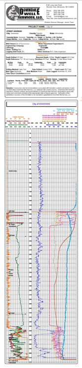
Downhole Well Services imaging systems feature the Mount Sopris
Instruments MGXII digital logger, the CUES Radial View Color (RVC) high-resolution,four
inch video camera and the Aries Axial View Color (CCV) two inch video
camera. For a close up of the video, click
here. 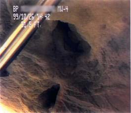 The RVC camera
(Radial View Color), with its fully articulating lens, is housed in a
pressure-resistant stainless-steel body that is lowered into the well on
triple armored 2000 foot coaxial cable. The new low-lux features of this
camera allow for the most detailed inspection of all well features
offered to date. The CCV camera, with its axial view fixed lens, is also
housed in a pressure-resistant stainless-steel body that is easily
interchangeable with the RVC camera on the end of the 2000-foot coaxial
cable. Once lowered, both cameras provide a continuous visual log of the
casing, borehole, or screen. The image is transmitted to a monitor, in a
climate controlled 14.5 feet cube van, providing real-time viewing of
the inspection and simultaneously recording on three VHS tapes and
capturing digitally on a laptop hard drive for DVD output. In addition,
the image is transmitted to a SONY UP-20 Color Video Printer that
instantly prints hard copy pictures of the screen image. Our water
resources staff, having experience of over 1,500 well video inspections,
then analyzes the field recorded video tapes and subsequently burned
digital disks.
The RVC camera
(Radial View Color), with its fully articulating lens, is housed in a
pressure-resistant stainless-steel body that is lowered into the well on
triple armored 2000 foot coaxial cable. The new low-lux features of this
camera allow for the most detailed inspection of all well features
offered to date. The CCV camera, with its axial view fixed lens, is also
housed in a pressure-resistant stainless-steel body that is easily
interchangeable with the RVC camera on the end of the 2000-foot coaxial
cable. Once lowered, both cameras provide a continuous visual log of the
casing, borehole, or screen. The image is transmitted to a monitor, in a
climate controlled 14.5 feet cube van, providing real-time viewing of
the inspection and simultaneously recording on three VHS tapes and
capturing digitally on a laptop hard drive for DVD output. In addition,
the image is transmitted to a SONY UP-20 Color Video Printer that
instantly prints hard copy pictures of the screen image. Our water
resources staff, having experience of over 1,500 well video inspections,
then analyzes the field recorded video tapes and subsequently burned
digital disks.
Downhole Well Services geophysical logging system
features the MGXII
logger with multi-sensor stacking probes. The MGXII logger offers
multi-sensor stacking probes measuring up to nine parameters
simultaneously. It also has the ability to display data in real-time as
the probes are raised, enabling immediate field analysis. Upon arrival
in the office, geophysical and acoustic data are redisplayed for
analysis and interpretation. Interpreted data displays are then
presented for review, i.e. correlation with surrounding interpreted
wells, to the appropriate State Agency. Finally data is redisplayed,
including the final interpretation, and distributed to the client.
Click here to see a close up of the
chart.
Our water well video inspection system along with our geophysical logging capability allows us to obtain information about specific wells as an aid in determining the best method to rehabilitate or augment the efficiency of the well. Our ability to actually observe in-situ well conditions is a tremendous tool in the evaluation of water systems.
To view our equipment and the videos it produces Click here.
Copyright(c) 2005-2006 Downhole Well Services, LLC. All rights reserved.
webmaster